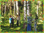
- Orientation to Local Habitat and Study Site
- Description of Geological Exposure
- Profile of River Valley Slope
- Soil Profile Pit
- Forest Health Based on Observations of Coniferous Trees
- Species Composition and Abundance of Fungi
- Census of Birds Using Line Transect Counting Method
- Integrated Study of Landscape Profile
- Environmental Assessment of Human Impact
- Assessment of Air Pollution Using Lichen Bioindication
Ecological Field Studies Techniques Video 4CD Set:
It is possible to purchase the complete set of 40 seasonal Ecological Field
Studies Techniques Video (in mpg format) in an attractive 4 compact disk set.
These compact disks are compatible with Mac and PC computers.
The videos are suitable for individual student or whole class instruction. To purchase the complete 4CD set
write to ecosystema1994@yandex.ru in a free form.

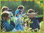
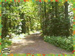
This lesson is the introduction to the Autumn series of ecological field
studies. The focus is on working with a map and compass, designing simple orienteering
routes and organization of a student competition.
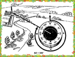
The lesson begins with the basics of compass and map skills. Students will learn the
structure of a compass, the basic functions of its components and skills such as finding
directions and rotating the compass rose. |
 |
 |
The next skill is determining an azimuth, the angle from magnetic north
to any object. The azimuth measurement will be used in future ecological field studies to
organize data collection techniques. |
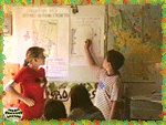
| Next students learn to work with a map. Students will be able to
recognize specific real objects charted on the map and orient the map to the cardinal
directions. Students will use the map for orienteering and determining the main features
of an orienteering study route used for student competitions. |
 |
 |
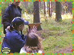
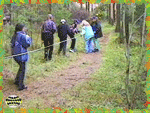
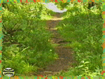
At "Ecosystem" there is an established orienteering route in
the form of a loop 1.5 km long. The route follows existing roads and paths. Student
checkpoints are hidden in the forest at a specific distance from the route. At each
checkpoint, students find words which form a phrase.
Students work in groups of 2 or 3. The goal is to run along the route as quick as possible
and to find as many words as they can. Overall team results (the score) of the competition
in-cludes net time of going along the route and the number of correctly found words. |

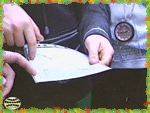
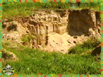
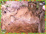
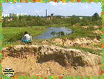
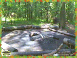
This field study focuses on formation of alluvial sedimentation in a
river valley. Students learn guidelines for profile site selection, preparation of a
profile pit, how to describe the expo-sures and presentation of the results
The field study starts with the selection of a river valley section, where all river
sedimentation, i.e. alluvium, will be studied. The best sample sites can be found on a
flat smooth river bank with natural cliffs, preferably at the border between the flood
plain and upland terraces. |
 |
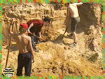 |
Preparation of the profile site begins with exposing the geological
layers, trying not to damage natural deposits of horizons. While cleaning, it is
recommended to make the wall vertical and under no conditions can anyone step on its top
surface edge. |
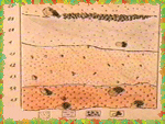
Each horizon is described according to: top and bottom borders of the horizon, main
distinctive features, color, hardness and mechanical structure. The occurrence of
inclusions is also specified for each horizon.
Based on the descriptions, students answer the following questions: how was the given area
formed, what role did the river play in its shaping, what materials compose the geologic
structure, where did they originate, etc. |
 |
 |
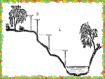
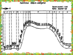
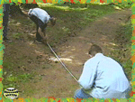
This lesson describes construction of an inexpensive, simple leveling
instrument, aspects of selecting a site for determining slope, the techniques of leveling
and a method for plotting the slope profile. |
| The selection of the field study site is based on the occurrence of a
relatively steep slope without vegetation within a direct line of sight from the bottom to
the top of the slope. Students will make successive measurements of the incline moving up
the slope at intervals of 1 m. |
 |
 |
We recommend having teams of three students conduct the leveling survey. Two students
work with the bottom level, the third member of the team takes another level and places it
at the upper point, that is the distance of exactly one meter higher than the first point.
Next students measure the distance between the lower and upper points with a measuring
tape. The procedure is repeated along the slope - from the bottom to the top. |
| Following data collection, students plot the slope profile. The result is a schematic
drawing of the slope as a side view based on the field data. The slope profile technique
and its use are emphasized in subsequent ecological field studies. |
 |
 |
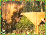
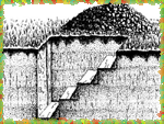
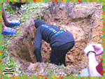
This field study describes guidelines for locating a soil profile pit,
construction of the profile pit, a procedure for soil profile description and
interpretation of the results. |
| The lesson begins with the selection of a sampling site and how to
prepare the soil pit. Criteria include the position and size of the pit, how to remove the
soil, construction of access stairs and procedures for exposing the front pit wall. |
 |
 |
The next step is the "dissection" of the front wall. Careful
exposure of the soil pit wall is necessary for determination of the soil structure,
revealing new formations and evaluation of the density of different horizons. |
| Students then determine basic morphological features for each soil
horizon. These include: mechanical composition, soil structure and texture, presence of
new formations and inclusions such as roots, stones and burrows of organisms living in the
soil. |
 |
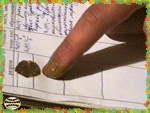 |
In order to record the actual colors of soil horizons, soil smears are
made on the description form. Samples are taken from each horizon, moistened and smeared
on the diagram with a finger. |
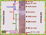
| Following the actual field experiences students analyze the results and
explain the basic soil-forming processes at the study site. The results of the study and
analyses of the soil profile scheme indicate where soil horizons and functional soil zones
are located and how they were formed. |
 |
 |
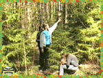
This study begins a series of lessons devoted to environmental monitoring
using bioindication methods. This is an assessment of ecosystem status based on species
bioindicators. |
| In this study of the forest ecosystem, students monitor pine trees (Pinus
family) as a bioindicator. The field aspect of the study consists of the description of
specific features of the trees from ground level. |
 |
 |
The work begins with marking of the study site with the assumption that
monitoring will continue for several years. Each tree marked in the study site must be
closely examined with the help of binoculars. |
The description itself consists of a visual assessment of each tree
according to a number of obvious features, such as: defoliation of the crown, the degree
of the crown discoloring, the number of cones and the growth of end shoots.
Several sites are studied. Students construct bar graphs of the percentage ratio of
different trees at the study sites. The more trees with high values, the worse the
conditions at that par-ticular site. These diagrams make vivid illustrations when
comparing several different sites. |
 |
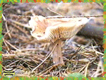 |
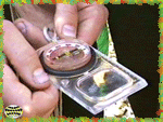
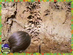
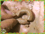
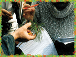
The objectives of this study are to collect and determine as many fungi
species as possible in a given area, count approximate numbers per unit of area, and
determine overall density.
The procedure for counting fungi is relatively simple. A group of students will travel
along a random, but straight-line transect. Students collect one specimen of each species
and record the occurrence of all other individuals of that type. |
| When data collection is finished a total distance not less than one km
should be covered. In order to estimate the study area, students multiply the width of the
entire line transect by the length or distance covered. Then determine the number of fungi
per unit of area. |
 |
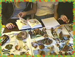 |
Sorting of specimens and determination of fungi species is a significant
part of the work. This should be done in the laboratory. All collected fungi are sorted
according to their external features and each student compares his collected specimens
with the class collection.
While preparing the report, special attention should be paid to species diversity, that
is, what species are the most abundant and what species are rare. Students may also
provide de-scriptions of the most interesting fungi species - their biological
peculiarities and which are edible and poisonous. |
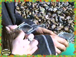
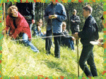
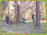
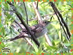
In this field study students conduct line-transect counts of birds and
estimate each species density per one square unit in a selected habitat.
Due to the fact that birds' census is technical work and because researchers should know
how to determine bird's species not only by appearance, but also by voice, the teacher
should pay special attention to training student counters in advance. |
 |
 |
Specific guidelines for the field study include: the census should be
carried out in the morning, when birds are most active, it should be carried out in good
weather and in absence of wind and rain, it should be carried out by two or three
students. |
| Census data is consolidated in a table of all bird observations in the
selected type of the habitat. Then the population density per 1 square kilometer is
calculated for each of the identified bird species. Finally the data is summarized on a
map of the field study site. |
 |
 |
In this field study students analyze the interrelationships of
topography, soil and vegetation. This activity is a continuation of the river valley slope
profile and focuses on in-depth study of associated vegetation and soils. |
| When choosing the location of a site, it is best to find an area, where
various, distinctive types of plant associations - from dry to wet - are found. Then
interrelations among relief, vegetation and soils will be distinct and clear, and the
results of the student analysis will be vivid. |
 |
 |
Geobotanical study starts with the determination of plant associations
found along the slope profile line. Work begins with the description of the tree layer,
where general crown closure should be evaluated, as well as species composition and
relationship within the tree canopy. |
| After the tree canopy is described, then the understory, that is, young
trees which will become the predominant species and trees and bushes which will not form
the forest canopy are described. |
 |
 |
Along with geobotanical research, soils are also studied using the soil
profile pit method. The soil profile is carried out according to a standard procedure
where all relevant informa-tion is collected including the location of the profile and
characteristics of all soil horizons. |
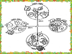
| When organizing study results for the final presentation, all three
landscape components should be visually shown: relief - with the help of the profile line;
vegetation - with the help of a species legend; and soil - illustrated by colorful
diagrams of the soil profiles. |
 |
 |
This field study allows students to quantitatively evaluate different
forms of human impact on an area, such as anthropogenic forms of relief, damages of soil,
vegetation and presence of synanthropic animal species.
All anthropogenic objects, found in the forests area can be divided into three groups: 1)
"measurable" objects - they are different in length; 2) "unmeasurable"
objects - these objects usually have "standard size" (pipelines, electric power
lines, etc), and "spot" or "point" objects. |
| Measurable objects include ditches, pits, embankments and bars created by
humans, roads, paths, large soil trampling areas, forest cutting areas, burned out forest
areas and felling grounds. |
 |
 |
During route counting, length of other objects, such as garbage
landfills, quarries, water bodies, agricultural lands, cattle pastures and passages and
other large objects created by humans, should be measured. |
| "Spot" objects, which are counted within a band of a chosen
width, include campfire sites, dry and top-drying trees, wounded trees and synanthropic
species such as dogs and cats. |
 |
 |
The counting procedure for these studies is very simple: a group of
students walk along a straight line according to compass orientation, compass bearings are
taken occasionally based on the initial direction. Measurements results are recorded in
the form of a table in the field diary. |
| Student data is processed for each group of objects separately. For
"measurable" objects, their length is summed and the fraction of each object's
total length of the route (in %) is calculated and recorded in the table. All
"spot" objects, which were registered in the counting band, are summed. Then
their density value per area unit (for example, 1 sq. km) is counted. The number of
"unmeasurable" objects is estimated per 1 linear km of the route. |
 |
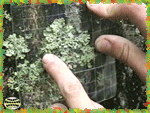 |
This ecological monitoring method assesses the degree of air pollution
based on presence and abundance of epiphytic lichens found in the local environment.
The ecological field study focuses on the abundance of different lichens at chosen sites.
Abundance can be determined with the help of an easily constructed transparent grid, i.e.
a frame divided into squares. |
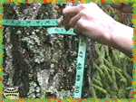
| Another measurement technique useful for tree samples is based on linear
intersections, where the diameter of the tree trunk is considered 100%, and the lengths of
all the lichen thalluses along the measuring tape are recorded and then added, then lichen
cover is calculated as a percentage. |
 |
 |
The basic guidelines for lichen research are: there should be many
sampling sites, lichen samples should be studied in the same types of environment and on
the same types of surfaces and abundance and numbers of lichens should be measured using a
single methodology. |
| When studying large areas (dozens of kilometers), species composition
should be the level of data acquisition, this approach can help indicate relative polluted
zones. It is recommended to study abundance of lichens in smaller areas where there may be
local sources of pollution. |
 |
Ecological Field Studies Techniques Video 4CD Set:
It is possible to purchase the complete set of 40 seasonal Ecological Field
Studies Techniques Video (in mpg format) in an attractive 4 compact disk set.
These compact disks are compatible with Mac and PC computers.
The videos are suitable for individual student or whole class instruction. To purchase the complete 4CD set
write to ecosystema1994@yandex.ru in a free form.
Ecological Field Studies Demo Disk:
We also have a free and interesting demonstration disk that explains our ecological field studies approach.
The demo disk has short excerpts from all the seasonal field study videos as well as sample text from all the teacher manuals.
The disk has an entertaining automatic walk through which describes the field study approach and explains how field studies meet education standards.
You can also download the Demo Disc from ecosystema.ru/eng/eftm/CD_Demo.iso.
This is a virtual hybrid (for PC and Mac computers) CD-ROM image (one 563 Mb file "CD_Demo.iso").
You can write this image to the CD and use it in your computer in ordinary way.
You also can use emulator software of virtual CD-ROM drive to play the disk directly from your hard disk.

|