This page contains the list of images of the Austrian and southern Germany (Eastern Alps)
nature: natural landscapes, vegetation types and some plants.
Clicking on the preview in the list below you will be transferred to the page with the
full sized image
(usually 1024 x 768 pixels and approximately 150 kilobytes).
Europe
AUSTRIA and GERMANY
Eastern Alps: Tirol, Carinthia, Salzburg, Steiermark, Bavaria
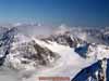
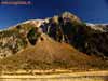
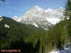
Pitztaler Glacier. Altitude is about 3300 meters above sea level.
Typical alpine relief in the glacier zone.
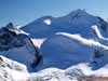
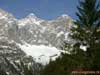
Ratische Alps - one of the Eastern Alps ridges
Typical alpine relief in the glacier zone in the Ratische Alps
(one of the Eastern Alps ridges). Altitude is about 3300 meters above sea level.
Pitztaler Glacier outskirts
Snow fields on the top of Ratische Alps (one of the Eastern Alps ridges).
Altitude is about 3400 meters above sea level.
Pitztaler Glacier outskirts
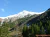
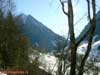
Eastern Alps, typical alpine relief in the glacier zone
(altitude is about 3000 meters above sea level) in the Stubaier Glacier outskirts.
Tirol, Neuschtift
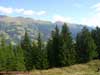
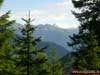
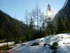
Altitude zoning in the Eastern Alps: the border between forest zone
and sub alpine meadows zone. Spruce-fir coniferous forests and
elfin wood. Altitude is about 2000 meters above sea level.
Eastern Alps, Tirol, Neuschtift
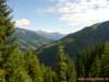
Altitude zoning in the Eastern Alps: the border between forest zone
and sub alpine meadows zone. Spruce-fir coniferous forests and
elfin wood. Altitude is about 2000 meters above sea level.
Eastern Alps, Tirol, Neuschtift
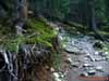
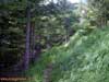
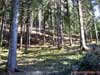
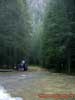
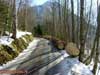
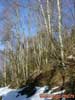
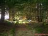
Mountain trail in the spruce-fir coniferous forest.
Altitude is about 1500 meters above sea level.
Eastern Alps, Tirol, Neuschtift
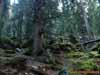
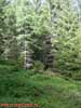
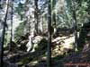
Spruce-fir coniferous forest.
Altitude is about 1500 meters above sea level.
Eastern Alps, Tirol, Neuschtift
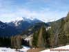
Alpine relief at the altitude zone between forest and sub alpine meadows zones.
Debris cone in the mountain river valley.
Altitude is about 1700 meters above sea level. Eastern Alps, Tirol, Neuschtift
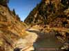
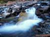
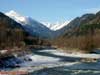
Mountain river bed and valley.
Altitude is about 1700 meters above sea level. Eastern Alps, Tirol, Neuschtift
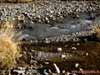
Mountain river bed.
Eastern Alps, Tirol, Neuschtift
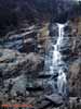
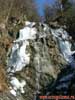
Waterfall on the small mountain river. Eastern Alps, Tirol, Neuschtift
Small mountain river. Eastern Alps, Tirol, Neuschtift
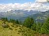
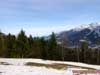
Altitudinal zonation in the Eastern Alps: the zone of coniferous forests with elements
of the cultural landscape changes with the zone of subalpine meadows. Heights of the peaks
are around 2500 m above sea level. Outskirts of the Lainach village, near the town of
Winklern. Hohe Tauern National Park, Carinthia, southern Austria
Coniferous spruce forests near upper forest zone border at an altitude of about 1800 m
above sea level. High-altitudinal zonation is visible in the distance: coniferous forests
change with the area of subalpine meadows. Hohe Tauern National Park, Carinthia, southern
Austria
The zone of the dark coniferous forests (spruce) in the Eastern Alps at an altitude of
about 1800 m above sea level. Far away - tops of a mountain range of the Hohe Tauern peaks
with a heights of about 3500 m above sea level. Hohe Tauern National Park, Carinthia,
southern Austria
The zone of dark coniferous forests (spruce) in the Eastern Alps at an altitude of
about 1800 m above sea level. Far away - tops of a mountain range of the Hohe Tauern peaks
with a height is about 3500 m above sea level. Hohe Tauern National Park, Carinthia,
southern Austria
Spruce dark coniferous forest with blueberries and grasses in the herb-shrub layer.
The height is about 2000 m above sea level. Outskirts of the Lainach village, near the
town of Winklern. Hohe Tauern National Park, Carinthia, southern Austria
Fir dark coniferous forest with blueberries and grasses in the herb-shrub layer. The
height is about 2000 m above sea level. Outskirts of the Lainach village, near the town of
Winklern. Hohe Tauern National Park, Carinthia, southern Austria
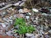
Blooming dendrantema (genus Dendranthema, Asteraceae family) in the dark coniferous
spruce forest. The height is about 2000 m above sea level. Carinthia, southern Austria
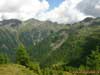
Altitudinal zonation in the Eastern Alps: the upper border of the coniferous forests
in the transition zone to the sub-alpine meadows. The height is about 2300 m above sea
level. In the distance - the Polinik peak (height 2784 m) in the mountain range Kreuzeck
Group (Kreuzeckgruppe). Outskirts of the Lainach village, near the town of Winklern. Hohe
Tauern National Park, Carinthia, southern Austria
Altitudinal zonation in the Eastern Alps: the zone of coniferous forests changes with
the zone ofsubalpine meadows. Heights of the peaks are about 2700 m above sea level.
Mountain range Kreuzeck Group (Kreuzeckgruppe), in the vicinity of village Lainach, near
the town of Winklern, Carinthia, southern Austria
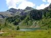
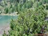
Lake Lussensee in the glacial origin basin (tarn). The height is about 2700 m above
sea level. Mountain range Kreuzeck Group (Kreuzeckgruppe), in the vicinity of Lainach
village, Eastern Alps, Carinthia, southern Austria
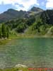
Lussensee lake in the glacial origin basin (tarn). The height is about 2700 m above
sea level. Mountain range Kreuzeck Group (Kreuzeckgruppe), in the vicinity of Lainach
village, Eastern Alps, Carinthia, southern Austria
Pine Elfin forest on the shore of the cirque (ice) lake Lussensee. The height is about
2700 m above sea level. Mountain range Kreuzeck Group (Kreuzeckgruppe), in the vicinity of
Lainach village, Eastern Alps, Carinthia, southern Austria
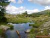
Creek, flowing from the cirque (ice) lake Lussensee. The height is about 2700 m above
sea level. Mountain range Kreuzeck Group (Kreuzeckgruppe), in the vicinity of Lainach
village, Eastern Alps, Carinthia, southern Austria
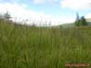
Boggy alpine meadow with predominance of cotton grass and sedges on the banks of the
Lussensee lake. The height is about 2700 m above sea level. Mountain range Kreuzeck Group
(Kreuzeckgruppe), in the vicinity of Lainach village, Eastern Alps, Carinthia, southern
Austria
Dark coniferous forests (spruce and larch) at the upper boundary of the forest
altitudinal zone on the northern slope of Hohe Tauern mountain range. The height is about
2000 m above sea level. Hohe Tauern National Park, Carinthia, southern Austria
Dark coniferous forests (spruce and larch) at the upper boundary of the forest
altitudinal zone on the northern slope of Hohe Tauern mountain range. The height is about
2000 m above sea level. Hohe Tauern National Park, Carinthia, southern Austria
Plot light coniferous forests (larch) in the upper zone of high-altitude forests on
the northern slope of Hohe Tauern mountain range (the cloud rises from the valley). The
height is about 2000 m above sea level. Hohe Tauern National Park, Carinthia, southern
Austria
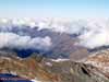
Altitudinal zonation in the Hohe Tauern mountain range: the zone of coniferous forests
change with the nival belt at an altitude of 3,000 m above sea level. Hohe Tauern National
Park, Carinthia, southern Austria
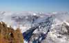
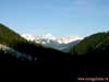
Isel river valley, flowing from the southern slope of the Hohe Tauern mountain range.
Far right - Mount Grossglockner – the highest mountain in Austria and Eastern Alps
(altitude 3798 m), on the left – Mount Grossvenediger, height is 3674 m. Neighborhood of
the village Ainet, Hohe Tauern National Park, Carinthia, southern Austria
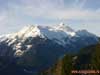
View of the Hohe Tauern mountain range, Mount Grossglockner (right away) - the highest
peak of Austria and the Eastern Alps (altitude 3798 m) and Mount Grossvenediger (3674 m,
center) from the southern macroslope. Neighborhood of the village Ainet, Hohe Tauern
National Park, Carinthia, southern Austria
View to the Mount Grossvenediger (altitude 3674 m) from the southern macroslope of the
Hohe Tauern mountain range. Neighborhood of the village Ainet, Hohe Tauern National Park,
Carinthia, southern Austria
Dark coniferous green moss (Hylocomium) spruce and fir forest on the slopes of the
Hohe Tauern mountain range. Neighborhood of the village Ainet, Hohe Tauern National Park,
Carinthia, southern Austria
Dark coniferous green moss (Hylocomium) spruce and fir forest on the slopes of the
Hohe Tauern mountain range. Neighborhood of the village Ainet, Hohe Tauern National Park,
Carinthia, southern Austria
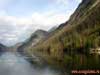
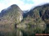
The lake Konigssee ("The Royal lake", or St. Bartholomew's lake) in the
glacial origin basin (probably "slide-rock" origin), surrounded by mixed and
broad-leaved forests on the slopes of mountains. Altitude is 603 m above the sea level.
Berchtesgaden National Park, Bavaria, southern Germany on the border with Austria
The Konigssee lake ("The Royal lake", or St. Bartholomew's lake) in the
glacial origin basin (probably "slide-rock" origin), surrounded by mixed and
broad-leaved forests on the slopes of mountains. Altitude is 603 m above the sea level.
Berchtesgaden National Park, Bavaria, southern Germany on the border with Austria
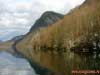
Shore of Lake Konigssee, covered with deciduous forests (oak, beech, maple) on the
slopes of Mount Watzmann. The altitude of the lake waters is 603 m above sea level.
Berchtesgaden National Park, Bavaria, southern Germany on the border with Austria
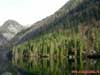
Mixed forests (spruce, oak) on the shores of Lake Konigssee (Konigsee) on the slopes
of Mount Watzmann. The altitude of the lake is 603 m above sea level. Berchtesgaden
National Park, Bavaria, southern Germany on the border with Austria
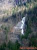
Falls on the slope of Mount Watzmann at the altitude of about 800 m above sea level.
Shore of Lake Konigssee (Konigsee), Berchtesgaden National Park, Bavaria, southern Germany
on the border with Austria
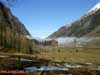
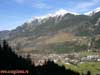
Altitudinal zonation on the northern slope of the Hohe Tauern mountain massif:
broad-leaved forests are replaced by dark coniferous forests and subalpine meadows,
passing into nival belt (on top). View of the city Badgastein, the altitude of the valley
is about 1000 m above sea level, the tops - 2700 m. Salzburg, Southern Austria
Dark coniferous forest (spruce, fir) on the northern slope of the Hohe Tauern mountain
massif, at an altitude of about 1,700 m above sea level. Outskirts of Bockstein town near
the entrance to the railway tunnel (Tauerntunnel). Salzburg, Southern Austria
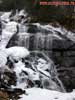
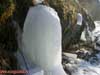
Freezing waterfall on the slopes of the Hohe Tauern mountain range, at an altitude of
about 1,700 m above sea level. Outskirts of Bocksteintown near the entrance to the
railway tunnel (Tauerntunnel). Salzburg, Southern Austria
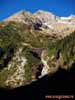
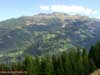
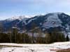
Dachstein Mountain Ridge (Dachsteingruppe) with the top Hoherdachstein (2995 m). View
from the Hohe Tauern mountain range at the area between Radstadt and Obertauern. Salzburg,
Southern Austria
Middle-aged coniferous forests (spruce and fir) in the river valley on the northern
macroslope of the Hohe Tauern mountain massif, at an altitude of about 1,700 m above sea
level in the area between Radstadt and Obertauern. Salzburg, Southern Austria
Dark coniferous forest (spruce, fir) and local logging on the northern macroslope of
the Hohe Tauern mountain massif, at an altitude of about 1,700 m above sea level in the
area between Radstadt and Obertauern, Salzburg, Southern Austria
Coniferous (pine) heather-bilberry forest with a mixture of spruce and fir on the
slopes of the Dachstein mountain range (Dachsteingruppe). The height is about 2000 m above
sea level. The surroundings of Ramsau am Dachstein, Steiermark, southern Austria
Crowberry (Empetrum, Ericales) in the light-coniferous pine forest with a mixture of
spruce and fir on the slopes of the Dachstein mountain (Dachsteingruppe). The height is
about 2000 m above sea level. The surroundings of Ramsau am Dachstein, Steiermark,
southern Austria
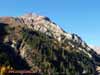
Dachstein Mountain Ridge with the top of Hoherdachstein (2995 m) with dark coniferous
spruce forests on the slopes - karst mountain area, the second highest mountain in the
Northern Limestone Alps. The surroundings of Ramsau am Dachstein, Steiermark, southern
Austria
Mountain Ridge Dachstein with the top Hoherdachstein (2995 m) with a dark coniferous
spruce forests on the slopes - karst mountain range, the second highest mountain in the
Northern Limestone Alps. The surroundings of Ramsau am Dachstein, Steiermark, southern
Austria
Broad-leaved forests on the northern macroslope of the Hohe Tauern mountain massif, at
an altitude of 1900 m above sea level. The piedmont of the Grossglockner mountain on the
Grossglocknerstrasse road, closed for travel in winter. Salzburg, Southern Austria
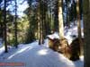
Mountain forest road and harvested timber on the northern marcoslope of the Hohe
Tauern mountain massif, at an altitude of 1900 m above sea level. The piedmont of the
Grossglockner mountain on the Grossglocknerstrasse road, closed for travel in winter.
Salzburg, Southern Austria
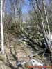
Narrow-leaved forest (birch, grey alder) at the foot of the Grossglockner mountain
range. Northern macroslope of the Hohe Tauern mountain range, height is about 1900 m above
sea level. Salzburg, Southern Austria
Narrow-leaved forest (birch, grey alder) at the foot of the Grossglockner mountain
range. Northern macroslope of the Hohe Tauern mountain range, height is about 1900 m above
sea level. Salzburg, Southern Austria
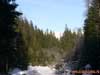
Frozen waterfall surrounded by small-leaved forests on the slopes of the Hohe Tauern
mountain range, at an altitude of 1900 m above sea level. Salzburg, Southern Austria
Frost - groundwater, frozen on the mountain slope. Narrow-leaved forest at the foot of
Mount Grossglockner. Northern macroslope of the Hohe Tauern mountain range, height is
about 1900 m above sea level. Salzburg, Southern Austria
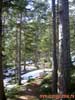
Mixed forests on the northern macroslope of the Hohe Tauern mountain massif, at an
altitude of 1900 m above sea level. The valley of the river Saale (Saalach) near the town
of Uttendorf, Salzburg, Southern Austria
Mixed forests on the northern macroslope of the Hohe Tauern mountain massif, at an
altitude of 1900 m above sea level. In the distance - the territory of the mountain
logging areas planted with young forest, at the bottom - the valley of the river Saale
(Saalach) near the town of Uttendorf, Salzburg, Southern Austria
The interior undercrown space (under the canopy) of middle age dark coniferous spruce
forest on the northern slope of the Hohe Tauern mountain massif, at an altitude of 1900 m
above sea level. Outskirts of Uttendorf, Salzburg, Southern Austria
From Photo Nature section of our site you can also download thousands images of fungi, lichens, plants and animals, made by professional Russian field biologists and geographers during their expeditions all over the Russia and former USSR republics. All objects from our collection are determined by scientist and have exact scientific name, date and place of taking picture, as well as size of the original image.
You are able to find necessary pictures using four different approach:
1) with a help of Geographic Index (all objects are separated by countries and nature geographical zones), 2) with a help of Systematic Index (all objects are separated by their systematic position),
3) with a help of Alphabetical Index (all objects are separated by their scientific Latin names according to the alphabet), and
4) with a help of Search Form (you can search scientific (Latin) names of species, genus, family, or order).
Our Field Ecology Center published more than
180 methodical materials for nature studies. Some of them are in English: