This page contains the list of images of Andorra and Eastern Pyrenees nature: natural landscapes and vegetation types.
Clicking on the preview in the list below you will be transferred to the page with the full sized image
(usually 1024 x 768 pixels and approximately 150 kilobytes).
EUROPE
EASTERN PYRENEES
PRINCIPALITY OF ANDORRA
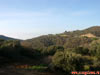
Broadleaved forest in the foothills of the Pyrenees Mountains on the way from Barcelona to Andorra. Spain, Catalonia.
Broad-leaved forests and agricultural fields in the foothills of the Pyrenees Mountains on the way from Barcelona to Andorra. Spain, Catalonia.
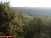
Pasture for sheep and cattle, the slopes of the Pyrenees Mountains covered with maquis (macchia) and garrigue (phrygana), as well as the upper outskirts of the city of Andorra La Vella. The altitude of 1250 m above the sea level. Eastern Pyrenees, Principality of Andorra.
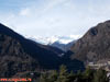
The slopes of the Pyrenees Mountains, covered with maquis (macchia) and garrigue (phrygana) - xerophytic shrubs and juniper, and snow-covered mountain range with peaks 2400-2900 meters above sea level. Eastern Pyrenees, Principality of Andorra.
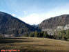
The slopes of the Pyrenees Mountains, covered with mixed and light-coniferous forests with a predominance of Oak (Quercus), Gray Alder (Alnus incana), Scots Pine (Pinus sylvestris) and Black, or Austrian Pine (Pinus nigra). The altitude is about 1500 meters above sea level. Eastern Pyrenees, Principality of Andorra.
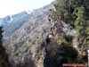
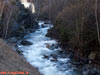
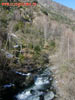
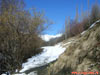
The rocky bed of the mountain river Valira (Valira D'orient), flowing down the slopes of the Pyrenees Mountains, surrounded by mixed forests with a predominance of Gray Alder (Alnus incana), birch (Betula) and fir (Abies). The altitude is about 1200 meters above sea level. Eastern Pyrenees, Principality of Andorra.
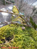
Green moss and ivy (Hedera helix) on a Hiking trail, laid on the slope of the Pyrenees Mountains over the city of Andorra La Vella, surrounded by a broad-leaved forest dominated by beech (Fagus). The altitude is about 1200 meters above sea level. Eastern Pyrenees, Principality of Andorra.
The rocky bed of the mountain river Valira (Valira D'orient), flowing down the slopes of the Pyrenees Mountains, surrounded by mixed forests with a predominance of Gray Alder (Alnus incana), Birch (Betula) and Fir (Abies). The altitude is about 1200 meters above sea level. Eastern Pyrenees, Principality of Andorra.
Blooming bush of Hazel (Corylus avellana) on the edge of the hiking trail along the slopes of the Pyrenees Mountains through meadow clearings in the zone of mixed forests from Andorra La Vella to the village of La Massana (Vallnord). The altitude is about 1400 meters above sea level. Eastern Pyrenees, Principality of Andorra.
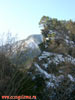
The mountain range of the Pyrenees Mountains in the mixed forest zone with a predominance of Gray Alder (Alnus incana), Scots Pine (Pinus sylvestris) and Black, or Austrian Pine (Pinus nigra). The height of 1300-1600 m above sea level. Eastern Pyrenees, Principality of Andorra.
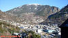
Panorama of the river Valira (La Valira) valley and views of the city of Andorra La Vella - the capital and the only city of the Principality of Andorra surrounded by the Pyrenees Mountains with a well-marked altitude vegetation zones - deciduous (beech) forests at the bottom of the slopes, mixed forests (in the middle part), light-coniferous (pine) forests in the upper part and subalpine meadows at the tops. The height of the peaks is 2600 meters above sea level. Eastern Pyrenees, Principality of Andorra.
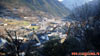
View of the river Valira (La Valira) valley and the city of Andorra La Vella - the capital and the only city of the Principality of Andorra surrounded by the Pyrenees Mountains, covered with broad-leaved (beech) forests in the lower slopes, and light-coniferous (pine) forests in the middle. Eastern Pyrenees, Principality of Andorra.
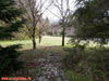
City park in the floodplain of the river Valira (La Valira) in the city of Andorra La Vella. Eastern Pyrenees, Principality of Andorra.
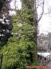
General view of the Ivy (Hedera helix) evergreen vine, on a hiking trail on the slope of the Pyrenees Mountains over the city of Andorra La Vella, surrounded by a broad-leaved beech (Fagus) forest. The altitude is about 1200 meters above sea level. Eastern Pyrenees, Principality of Andorra.
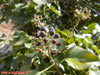
Mature fruits (berries) of the Ivy (Hedera helix) vine on a hiking trail along the slope of the Pyrenees Mountains over the city of Andorra La Vella, surrounded by a broad-leaved beech (Fagus) forest. The altitude is about 1200 meters above sea level. Eastern Pyrenees, Principality of Andorra.
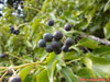
Mature fruits (berries) and whole leaves of fruit-bearing ivy shoots (Hedera helix) on a hiking trail over the slopes of the Pyrenees Mountains, surrounded by a broad-leaved beech (Fagus) forest. The altitude is about 1200 meters above sea level. Eastern Pyrenees, Principality of Andorra.
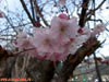
Plum flowers (Sakura) on the Central embankment of the Valira (La Valira) river in the center of Andorra La Vella town. Eastern Pyrenees, Principality of Andorra.
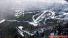
Panorama of the mountain ranges of the Pyrenees Mountains in the upper part of the slopes - in the vegetation zones of light coniferous forests with predominance of Scots Pine (Pinus sylvestris) and Black, or Austrian Pine (Pinus nigra) and subalpine meadows on the tops. Height 1700-2200 meters above sea level, ski resort Grandvalira - the largest ski area in southern Europe. Eastern Pyrenees, Principality of Andorra.
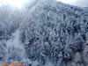
Snow-covered dark-coniferous forest of Spruce (Picea) and Fir (Abies) after a night of snow on the slopes of the Pyrenees Mountains. Eastern Pyrenees, Principality of Andorra.
Panorama of the mountain ranges of the Pyrenees Mountains, covered with light coniferous (pine) forests in the middle of the slopes and subalpine meadows in the upper part. Height 1700-2200 meters above sea level, ski resort Grandvalira - the largest ski area in southern Europe. Eastern Pyrenees, Principality of Andorra.
Panorama of the Pyrenees Mountains, covered with light-coniferous (pine) forests in the middle of the slopes and ski slopes of the resort of Vallnord. Height 1400-2000 meters above sea level, the Principality of Andorra.
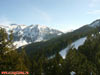
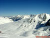
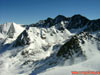
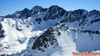
Panorama of the mountain ranges of the Pyrenees Mountains in their highest part in the zones of subalpine and alpine meadows. The altitude of 2000-2600 meters above sea level. Eastern Pyrenees, the border of the Principality of Andorra and France in the village of Pas de La Casa, ski resort Grandvalira.
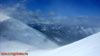
The tops of the mountain ranges of the Pyrenees Mountains in the zones of subalpine and alpine meadows. Altitude 2400-2800 meters above sea level. Eastern Pyrenees, the border of the Principality of Andorra and France in the village of Pas de La Casa.
The tops of the mountain ranges of the Pyrenees Mountains in the zones of subalpine and alpine meadows. Altitude 2400-2800 meters above sea level. Eastern Pyrenees, the border of the Principality of Andorra and France in the village of Pas de La Casa.
Panorama of the mountain ranges of the Pyrenees Mountains in their highest part in the zones of subalpine and alpine meadows. The altitude of 2000-2600 meters above sea level. Eastern Pyrenees, the border of the Principality of Andorra and France in the village of Pas de La Casa, ski resort Grandvalira.
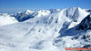
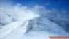
Snowstorm on the tops of the Pyrenees Mountains in the area of subalpine and alpine meadows. The altitude of 2000-2400 meters above sea level. Eastern Pyrenees, the ski area of Vallnord, the Principality of Andorra.
Snowstorm on the tops of the Pyrenees Mountains in the zones of subalpine and alpine meadows. The altitude of 2000-2400 meters above sea level. Eastern Pyrenees, the ski area of Vallnord, the Principality of Andorra.
From Photo Nature section of our site you can also download thousands images of fungi, lichens, plants and animals, made by professional Russian field biologists and geographers during their expeditions all over the Russia and former USSR republics. All objects from our collection are determined by scientist and have exact scientific name, date and place of taking picture, as well as size of the original image.
You are able to find necessary pictures using four different approach:
1) with a help of Geographic Index (all objects are separated by countries and nature geographical zones), 2) with a help of Systematic Index (all objects are separated by their systematic position),
3) with a help of Alphabetical Index (all objects are separated by their scientific Latin names according to the alphabet), and
4) with a help of Search Form (you can search scientific (Latin) names of species, genus, family, or order).
Our Field Ecology Center published more than
180 methodical materials for nature studies. Some of them are in English: