This page contains the list of images of the Central Andes and
Amazonian Lowland (Peru) nature: natural landscapes, vegetation types and some plants
and animals.
Clicking on the preview in the list below you will be transferred to the page with the
full sized image
(usually 1024 x 768 pixels and approximately 150 kilobytes).
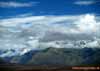
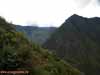
The Eastern Cordillera mountains on the way from Cusco (Cuzco) to Machu Picchu.
The mountain steppe - puna is in the middle altitude zone of the slope (about 3000 meters
above sea level).
The height of the peaks are 5000 m above sea level.
The eastern slopes of the Central Andes, or Sierra, Cusco (Cuzco) Department, Eastern Peru
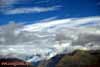
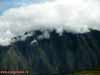
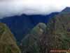
The Eastern Cordillera mountains slope on the way from Cusco (Cuzco) to Machu Picchu
in the middle altitude zone (about 3000 meters above sea level).
The eastern slopes of the Central Andes, or Sierra, Cusco (Cuzco) Department, Eastern Peru
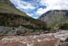
The valley of Urubamba river not far from Machu Picchu.
The elevation is about 2500 m above sea level.
The Eastern Cordillera mountains, Central Andes, or Sierra, Cusco (Cuzco) Department,
Eastern Peru
The valley of Urubamba river not far from Machu Picchu.
The elevation is about 2500 m above sea level.
The Eastern Cordillera mountains, Central Andes, or Sierra, Cusco (Cuzco) Department,
Eastern Peru
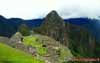
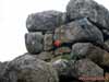
The world-famous Machu Picchu settlement ("Old mountain" in Quechua) -
the "Lost City" of pre-Columbian Inca civilization.
The Eastern Cordillera mountains, Central Andes, or Sierra, Cusco (Cuzco) Department,
Eastern Peru
The steep slopes of the Eastern Cordillera mountains, covered with mountain tropical
forest and shrubs.
The elevation is about 2500 m above sea level.
The Central Andes mountain system, or Sierra, Machu Picchu surroundings, Cusco (Cuzco)
Department, Eastern Peru
The steep slopes of the Eastern Cordillera mountains, covered with mountain tropical
forest and shrubs.
The elevation is about 2500 m above sea level.
The Central Andes mountain system, or Sierra, Machu Picchu surroundings, Cusco (Cuzco)
Department, Eastern Peru
The steep slopes of the Eastern Cordillera mountains, covered with mountain tropical
forest and shrubs.
The elevation is about 2500 m above sea level.
The Central Andes mountain system, or Sierra, Machu Picchu surroundings, Cusco (Cuzco)
Department, Eastern Peru
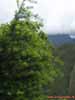
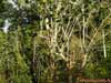
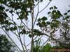
The Juniper sp. in the Eastern Cordillera mountains.
The elevation is about 2500 m above sea level.
The Central Andes mountain system, or Sierra, Machu Picchu surroundings, Cusco (Cuzco)
Department, Eastern Peru
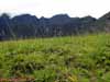
The typical vegetation of the mountain (alpine) meadows in the Eastern Cordillera
mountains.
The elevation is about 2500 m above sea level.
The Central Andes mountain system, or Sierra, Machu Picchu surroundings, Cusco (Cuzco)
Department, Eastern Peru
The unidentified flower in the Eastern Cordillera mountains.
The elevation is about 2500 m above sea level.
The Central Andes mountain system, or Sierra, Machu Picchu surroundings, Cusco (Cuzco)
Department, Eastern Peru
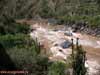
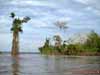
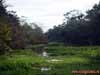
The Ucayali river - is the right branch (tributary) and one of two sources of the
Amazon River.
The Amazonian tropical forest zone between the Central Andes foothills and Amazonian
Lowland - the La Montanya region.
Near the city of Pucallpa, the Department of Ucayali, Eastern Peru near Brazil border
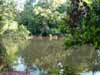
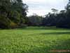
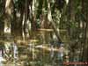
The Ucayali river cove growing with water vegetation (macrophytes).
The Amazonian tropical forest zone between the Central Andes foothills and Amazonian
Lowland - the La Montanya region.
Near the city of Pucallpa, the Department of Ucayali, Eastern Peru near Brazil border
The Ucayali river cove growing with water vegetation (macrophytes).
The Amazonian tropical forest zone between the Central Andes foothills and Amazonian
Lowland - the La Montanya region.
Near the city of Pucallpa, the Department of Ucayali, Eastern Peru near Brazil border
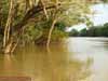
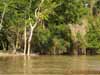
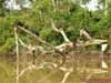
The Ucayali river during the rainy season (in summer flood).
The tropical forest zone (selva) between the Central Andes foothills and Amazonian Lowland
- the La Montanya region.
Near the city of Pucallpa, the Department of Ucayali, Eastern Peru near Brazil border
The Ucayali river during the rainy season (in summer flood).
The tropical forest zone (selva) between the Central Andes foothills and Amazonian Lowland
- the La Montanya region.
Near the city of Pucallpa, the Department of Ucayali, Eastern Peru near Brazil border
The Ucayali river during the rainy season (in summer flood).
The tropical forest zone (selva) between the Central Andes foothills and Amazonian Lowland
- the La Montanya region.
Near the city of Pucallpa, the Department of Ucayali, Eastern Peru near Brazil border
The Ucayali river during the rainy season (in summer flood).
The tropical forest zone (selva) between the Central Andes foothills and Amazonian Lowland
- the La Montanya region.
Near the city of Pucallpa, the Department of Ucayali, Eastern Peru near Brazil border
The Ucayali river during the rainy season (in summer flood).
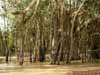
The Amazonian tropical forest with palm-trees, fever-trees, bamboo, ferns and arboreal
lianas predominance.
The tropical forest zone (selva) between the Central Andes foothills and Amazonian Lowland
- the La Montanya region.
Near the city of Pucallpa, the Department of Ucayali, Eastern Peru near Brazil border
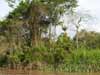
The Amazonian tropical forest with palm-trees, fever-trees, bamboo, ferns and arboreal
lianas predominance.
The tropical forest zone (selva) between the Central Andes foothills and Amazonian Lowland
- the La Montanya region.
The Ucayali river valley (Amazon river basin), near the city of Pucallpa, the Department
of Ucayali, Eastern Peru near Brazil border
The spider's web (cobweb) in the tropical forest.
The tropical forest zone (selva) between the Central Andes foothills and Amazonian Lowland
- the La Montanya region.
The Ucayali river valley (Amazon river basin), near the city of Pucallpa, the Department
of Ucayali, Eastern Peru near Brazil border
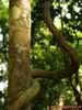
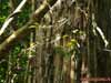
The arboreal liana in the tropical forest.
The tropical forest zone (selva) between the Central Andes foothills and Amazonian Lowland
- the La Montanya region.
The Ucayali river valley (Amazon river basin), near the city of Pucallpa, the Department
of Ucayali, Eastern Peru near Brazil border
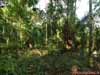
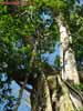
The stem of an old tree (tree trunk) in the tropical forest.
The tropical forest zone (selva) between the Central Andes foothills and Amazonian Lowland
- the La Montanya region.
The Ucayali river valley (Amazon river basin), near the city of Pucallpa, the Department
of Ucayali, Eastern Peru near Brazil border
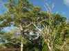
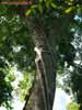
The old tree in the tropical forest.
The tropical forest zone (selva) between the Central Andes foothills and Amazonian Lowland
- the La Montanya region.
The Ucayali river valley (Amazon river basin), near the city of Pucallpa, the Department
of Ucayali, Eastern Peru near Brazil border
The arboreal liana in the tropical forest.
The tropical forest zone (selva) between the Central Andes foothills and Amazonian Lowland
- the La Montanya region.
The Ucayali river valley (Amazon river basin), near the city of Pucallpa, the Department
of Ucayali, Eastern Peru near Brazil border
The lobster-claws, or wild plantains or false bird-of-paradise flower
(Heliconia marginata - Heliconiaceae Family, Zingiberales Order) in the tropical forest.
The tropical forest zone (selva) between the Central Andes foothills and Amazonian Lowland
- the La Montanya region.
The Ucayali river valley (Amazon river basin), near the city of Pucallpa, the Department
of Ucayali, Eastern Peru near Brazil border
The termites (white ants) nest on the tree branch in the tropical forest.
The tropical forest zone (selva) between the Central Andes foothills and Amazonian Lowland
- the La Montanya region.
The Ucayali river valley (Amazon river basin), near the city of Pucallpa, the Department
of Ucayali, Eastern Peru near Brazil border
The Green Iguana, or Common Iguana (Iguana iguana) - the arboreal lizard, in the
tropical forest.
The tropical forest zone (selva) between the Central Andes foothills and Amazonian Lowland
- the La Montanya region.
The Ucayali river valley (Amazon river basin), near the city of Pucallpa, the Department
of Ucayali, Eastern Peru near Brazil border
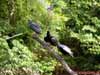
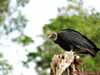
The Turkey Vultures (Cathartes aura) on the bank of Yarinacocha Lake.
The western region of the Amazonian Lowland in the Central Andes foothills.
Not far from the city of Pucallpa, the Department of Ucayali, Eastern Peru near Brazil
border
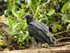
The young Turkey Vultures (Cathartes aura) on the bank of Yarinacocha Lake.
The western region of the Amazonian Lowland in the Central Andes foothills.
Not far from the city of Pucallpa, the Department of Ucayali, Eastern Peru near Brazil
border
The Turkey Vulture (Cathartes aura) on the bank of Yarinacocha Lake.
The western region of the Amazonian Lowland in the Central Andes foothills.
Not far from the city of Pucallpa, the Department of Ucayali, Eastern Peru near Brazil
border
The young Turkey Vulture (Cathartes aura) on the bank of Yarinacocha Lake.
The western region of the Amazonian Lowland in the Central Andes foothills.
Not far from the city of Pucallpa, the Department of Ucayali, Eastern Peru near Brazil
border
The young Turkey Vulture (Cathartes aura) on the bank of Yarinacocha Lake.
The western region of the Amazonian Lowland in the Central Andes foothills.
Not far from the city of Pucallpa, the Department of Ucayali, Eastern Peru near Brazil
border
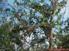
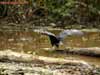
The Capped Heron (Pilherodius pileatus) in the tropical forest.
The Yarinacocha Lake surroundings. The western region of the Amazonian Lowland in the
Central Andes foothills.
Not far from the city of Pucallpa, the Department of Ucayali, Eastern Peru near Brazil
border
The Pale-throated, or Three-toed Sloth (Bradypus tridactylus)on the tree branch in the
tropical forest.
The tropical forest zone (selva) between the Central Andes foothills and Amazonian Lowland
- the La Montanya region.
The Ucayali river valley (Amazon river basin), near the city of Pucallpa, the Department
of Ucayali, Eastern Peru near Brazil border
From Photo Nature section of our site you can also download thousands images of fungi, lichens, plants and animals, made by professional Russian field biologists and geographers during their expeditions all over the Russia and former USSR republics. All objects from our collection are determined by scientist and have exact scientific name, date and place of taking picture, as well as size of the original image.
You are able to find necessary pictures using four different approach:
1) with a help of Geographic Index (all objects are separated by countries and nature geographical zones), 2) with a help of Systematic Index (all objects are separated by their systematic position),
3) with a help of Alphabetical Index (all objects are separated by their scientific Latin names according to the alphabet), and
4) with a help of Search Form (you can search scientific (Latin) names of species, genus, family, or order).
Our Field Ecology Center published more than
180 methodical materials for nature studies. Some of them are in English: