This page contains the list of images of the Northern India (Great and Lesser Himalayas) nature:
natural landscapes, vegetation types and some plants and animals.
Clicking on the preview in the list below you will be transferred to the page with the
full sized image
(usually 1024 x 768 pixels and approximately 150 kilobytes).
Asia
INDIA Great and Lesser Himalayas
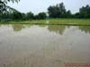
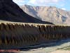
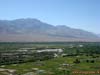
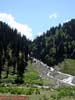
Rice paddies (flood-checks), Punjab, Northern India
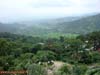
Man-made (anthropogenic) landscape in the foothills of the Himalayas
covered with coniferous and mixed (pine) forests. Himachal Pradesh, Northern India
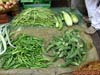
Vegetables in the local market: Beans (golden bean, or Mash - Vigna aureus
and May - Vigna mungo), Squash and the Chinese Bitter Gourd (Momordica charantia).
Himachal Pradesh, the district Dharmsala, Northern India
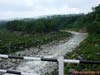
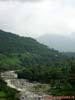
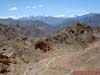
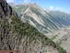
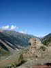
Tributary of the Beas river in the foothills of Pir-Pandzhal (extreme
north-west ridge of the Lesser Himalayas), covered with light-coniferous (pine) forests.
Himachal Pradesh, Northern India
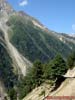
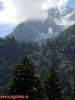
Mixed and light-coniferous (pine) forests on the slopes of the foothills
of Pir-Pandzhal (extreme north-west ridge of the Lesser Himalayas). Himachal Pradesh,
Northern India
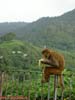
Rhesus monkeys, or bunder (Macaca mulatta) eating a banana. Foothills of
Pir-Pandzhal (extreme north-west ridge of the Lesser Himalayas). Himachal Pradesh,
Northern India
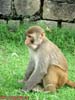
Rhesus monkeys, or bunder (Macaca mulatta) on the grass. Foothills of
Pir-Pandzhal (extreme north-west ridge of the Lesser Himalayas). Himachal Pradesh,
Northern India
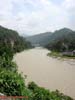
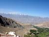
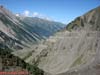
Beas River in the foothills of the Pir-Pandzhal ridge (Small Himalayas)
near the town of Mandi, covered with mixed and light-coniferous (pine) forests. Himachal
Pradesh, Northern India
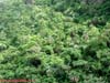
Evergreen rain forest from tall palm trees, laurel, tree ferns and bamboo
with many lianas and epiphytes on the slopes of the Lesser Himalayas. The valley of the
river Beas, Himachal Pradesh, Northern India
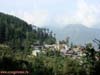
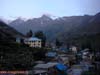
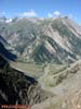
Naggar City in the Kulu (Kullu) Valley on the slopes of the Lesser
Himalayas, surrounded by coniferous (pine) forests. Height is about 2000 m above the sea
level, Himachal Pradesh, Northern India
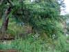
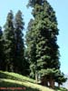
Deodar, or Himalayan cedar (Cedrus deodara) on the rocks in the Kulu
Valley (Kullu), the slopes of the Lesser Himalaya, Himachal Pradesh, Northern India
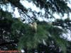
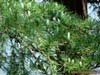
Branches and young buds of the Himalayan cedar (Cedrus deodara). The
slopes of the Lesser Himalayas, Kullu Valley (Kullu), Himachal Pradesh, Northern India
Branches and young buds of the Himalayan cedar (Cedrus deodara). The
slopes of the Lesser Himalayas, Kullu Valley (Kullu), Himachal Pradesh, Northern India
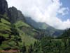
Coniferous forests dominated by fir average altitude zone near the border
with sub-alpine meadows in the Lesser Himalaya (about 3000 m above sea level). Kulu Valley
(Kullu), Himachal Pradesh, Northern India
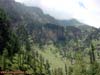
Coniferous forests with fir predominance in the average altitude zone
near the border with sub-alpine meadows in the Lesser Himalaya (about 3000 m above sea
level). Kulu Valley (Kullu), Himachal Pradesh, Northern India
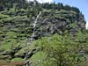
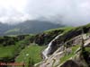
Waterfall trickling down the cliff in the dark coniferous forests Altitudinal
zone . Kulu Valley (Kullu), Himachal Pradesh, Northern India
Waterfall trickling down the cliff in the subalpine meadows altitude zone.
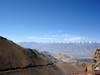
Mountains on the way to the Rattan pass (4000 m above sea level), the Great Himalayas
Range, Great Himalayas, Himachal Pradesh, Northern India
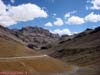
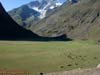
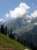
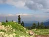
Altitudinal zone of alpine meadows in the alpine zone of the Great
Himalayas Range. Great Himalayas, the height from 3300 to 3800 m above sea level, Himachal
Pradesh, Northern India
Altitudinal zone of alpine meadows in the alpine zone of the Great
Himalayas Range. Great Himalayas, the height from 3300 to 3800 m above sea level, Himachal
Pradesh, Northern India
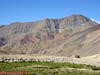
The bed of a mountain river Chenab with the floodplain deciduous forest
and terraced farming on the slopes in the Great Himalayas. Heights from 3300 to 3800 m
above sea level. Himachal Pradesh, Northern India
Keylong town in the Great Himalayas. Height is about 3350 m above sea
level. Himachal Pradesh, Northern India
Xerophytic juniper (Juniperus) sparse forest on the mountain slopes in the
Great Himalayas (Chandra River). Height is about 3800 m above sea level. Himachal Pradesh,
Northern India
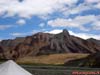
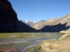
The valley of the Chandra-Ta river in the intermountain basin. The Great
Himalayas, height is about 3800 m above sea level. The road from Keylong to the Sarchu
pass. Himachal Pradesh, Northern India
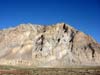
Apron (cone), accumulated talus at the foot of the mountains (the result
of the rocks denudation) in the Great Himalayas. Height is about 4000 m above sea level.
Himachal Pradesh, Northern India
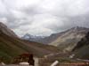
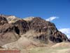
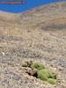
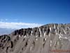
Altitudinal zone of the high (alpine) desert in the Great Himalayas, with
signs of active denudation of rocks. Height is about 4700 m above sea level. Himachal
Pradesh, Northern India
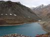
Highland (Alpine) Lake Depak-Tal in the valley of glacier type (stream,
dammed with the moraine) with signs of active denudation of the surrounding rocks. Height
is about 4700 m above sea level. Great Himalayas, Himachal Pradesh, Northern India
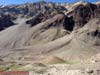
Altitudinal zone of the high (alpine) desert in the mountain hollow with
signs of active denudation of rocks. Great Himalayas Range Zaskar (Zanskar), height is
about 5,000 m above sea level. Jammu and Kashmir, Northern India
Alpine relief: altitudinal zone of the high (alpine) desert with active
denudation of metamorphosed sedimentary and crystalline rocks. Great Himalayas Range
Zaskar (Zanskar), height is about 5,000 m above sea level. Jammu and Kashmir, Northern
India
Alpine relief: accumulated talus (cone) at the foot of the mountains (the
result of denudation of metamorphosed sedimentary and crystalline rocks) in the
altitudinal zone of alpine desert. Great Himalayas Range Zaskar (Zanskar), height is about
5,000 m above sea level. Jammu and Kashmir, Northern India
Alpine relief: the classic cones - accumulated talus (cone) at the foot of
the mountains (the result of denudation of metamorphosed sedimentary and crystalline
rocks) in the altitudinal zone of alpine desert in Great Himalayas. Height is about 5500 m
above sea level. Ridge Zaskar (Zanskar), Jammu and Kashmir, Northern India
Water erosion of the mountain river banks - Carap river after Sarchu Pass
(Camp Sarchu) - a type of a denudation (destruction) of sedimentary rocks. The riverbed
cut the alluvial deposits filled the intermountain basin. Altitudinal zone of the alpine
desert in the Great Himalayas. Ridge Zaskar (Zanskar), height is about 5,000 m above sea
level. Jammu and Kashmir, Northern India
The horizontal layering of crystalline and sedimentary metamorphosed rocks
and cones (accumulated at the foot of talus, as a result of active denudation) in the
alpine desert in the Great Himalayas. Height is about 5,000 m above sea level. Himachal
Pradesh, Northern India
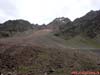
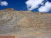
Huge talus - the result of a process of active denudation of rocks on the
tops of mountains in the Great Himalayas. Altitudinal zone of the alpine desert. Height is
about 5,000 m above sea level. Himachal Pradesh, Northern India
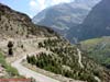
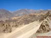
The road to the pass of La Lachang, built on a huge talus (scree slopes)
of the valley in the altitudinal zone of the alpine desert. Alpine relief, height is about
4,600 m above sea level. Himachal Pradesh, Northern India
Moss-covered rocks on the slope of the talus in the alpine wilderness of
the Great Himalayas. Ridge Zaskar (Zanskar), height is about 4,600 m above sea level.
Himachal Pradesh, Northern India
Ridge Zaskar (Zanskar) and springs in the Rumtze valley with alpine
meadows in the mountain hollow on a plateau in the Great Himalayas. Height is about 5,500
m above sea level. Himachal Pradesh, Northern India
Alpine relief on the ridge of Ladakh: scree (talus) near the top of the
mountains - the result of the rocks denudation processes on the tops of the Great Himalayans
altitudinal zone of the alpine desert. Height is about 5,000 m above sea level. Himachal
Pradesh, Northern India
Hemra Monastery and anthropogenic landscape with terraced farming on the
bottom of the Indus river valley. High-altitude plateau with signs of active denudation
and talus in the Great Himalayas at an altitude of 5,000 m above sea level. Himachal
Pradesh, Northern India
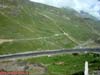
Anthropogenic (man-made) landscape with terraced, irrigated agriculture in
the bottom of the Indus river valley. High-altitude plateau with signs of active
denudation and talus in the Great Himalayas at an altitude of 4500 m above sea level. View
from the Monastery of Tiksi, Himachal Pradesh, Northern India
Alpine relief on the border between desert and alpine nival zones on the
ridge tops Zaskar (Zanskar), in the Great Himalayas. Visible in the distance is horizontal
layering of crystalline and sedimentary metamorphosed rocks. The height is 4,600 m above
sea level. Himachal Pradesh, Northern India
View of the Karakoram Mountain system and the Indus valley on the way from
Ladakh to the Kardung-La pass. Below is the valley of the Indus-river with irrigated
agriculture. Height is about 5600 m above sea level. Himachal Pradesh, Northern India
View of the Karakoram Mountain system and the Indus valley on the way from
Ladakh to the Kardung-La pass. Below is the valley of the Indus-river with irrigated
agriculture. Height is about 5600 m above sea level. Himachal Pradesh, Northern India
Ladakh mountain range, the view from the Kardung-La Pass (5600 m above sea
level). Alpine landscape: nival zone with signs of active denudation of rocks and talus on
the tops of Great Himalayas. Far away - Karakoram ranges. Himachal Pradesh, Northern India
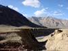
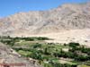
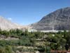
Anthropogenic (man-made) landscape with woody vegetation at the bottom of
a river valley in the mountain hollow, dividing ridges of Ladakh and the Karakoram. Nubra
valley, the river Shayok. Height is about 4500 m above sea level. Himachal Pradesh,
Northern India
Anthropogenic (man-made) landscape with trees and shrubs at the bottom of
a river valley in the mountain hollow that separates the Great and the Lesser Himalayas.
Height is about 4500 m above sea level. Himachal Pradesh, Northern India
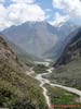
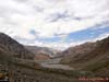
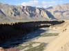
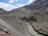
Floodplain and a riverbed of the Indus on the valley bottom, composed of
alluvial deposits in the intermountain basin that separates the Great and the Lesser
Himalayas. Height is about 4500 m above sea level. Himachal Pradesh, Northern India
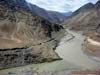
The merger of the Indus River (left) and Zanskar river (right), surrounded
by mountains, with the active processes of denudation and talus. Great Himalayas, region
of Ladakh, Zaskar Range (Zanskar), the height is about 4500 m above sea level. Himachal
Pradesh, Northern India
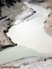
The merger of the Indus River (left) and Zanskar river (right), surrounded
by mountains with alluvial deposits and active processes of denudation and talus. Great
Himalayas, region of Ladakh, Zaskar Range (Zanskar), the height is about 4500 m above sea
level. Himachal Pradesh, Northern India
Indus River, cutting the canyon through the ridge with traces of active
denudation and talus slopes. Great Himalayas, the height is about 4500 m above sea level.
Himachal Pradesh, Northern India
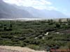
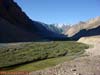
River Valley Drass with floodplain vegetation on alluvial deposits. Great
Himalayas, the height is about 4500 m above sea level. Himachal Pradesh, Northern India
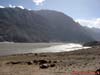
Meandering Drass riverbed, divided into branches with floodplain meadows
in alluvial deposits. Great Himalayas Range Zaskar (Zanskar), altitude about 4500 m above
sea level. Himachal Pradesh, Northern India
Meadows used as pastures on alluvial deposits in the valley of Drass river.
Great Himalayas Range Zaskar (Zanskar), altitude about 4500 m above sea level. Himachal
Pradesh, Northern India
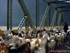
A herd of small ruminants (sheep and Angora goats) on the bridge over the
Drass river. Great Himalayas, Himachal Pradesh, Northern India
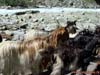
Goats in a herd of cattle. Great Himalayas Himachal Pradesh, Northern
India
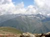
The slopes of the Great Himalayas Range, covered with dark coniferous
forests and coniferous woodland (fir, deodar, juniper). Altitude is 2,500 to 4,500 m above
sea level. Himachal Pradesh, Northern India
Altitudinal zonation in the Great Himalayas: coniferous forest (Himalayan
cedar, fir) – juniper woodlands - Alpine Meadows - Alpine Desert - nival belt at
altitudes from 2,500 to 4,500 m above sea level. Himachal Pradesh, Northern India
Altitudinal zonation in the Great Himalayas: coniferous forest (Himalayan
cedar, fir) – juniper woodlands - Alpine Meadows - Alpine Desert - nival belt at
altitudes from 2,500 to 4,500 m above sea level. Himachal Pradesh, Northern India
Altitudinal zonation in the Great Himalayas: coniferous forest (Himalayan
cedar, fir) – juniper woodlands - Alpine Meadows - Alpine Desert - nival belt from
altitudes of 2,500 to 4,500 m above sea level. Himachal Pradesh, Northern India
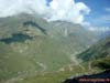
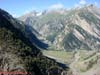
River Valley in the Great Himalayas, with altitudinal zones (belts) of
coniferous forests to alpine meadows at elevations from 2,500 to 4,000 m above sea level.
Himachal Pradesh, Northern India
Altitudinal zonation in the Great Himalayas in the zones (belts) of
coniferous forests (deodar, fir) to alpine meadows at elevations from 2,500 to 3,500 m
above sea level. From the left you can see an avalanche chute with scree and alluvial fans
at the bottom of the slope. Himachal Pradesh, Northern India
Old deodar (Cedrus deodara) in the area of dark-coniferous forests.
Sonmarg village (2740 m above sea level), the Great Himalayas Range, Great Himalayas,
Himachal Pradesh, Northern India
Altitudinal zonation in the Great Himalayas: coniferous forest (Himalayan
cedar, fir) – juniper woodlands - alpine desert - nival belt at elevations from 3,500 to
4,500 m above sea level. Himachal Pradesh, Northern India
A small mountain stream in the zone of mixed forests (deodar, fir and
oak). Height is about 2700 meters above sea level, the Great Himalayas Himachal Pradesh,
Northern India
Coniferous forests (deodar, fir) on the border with nival belt. Height -
2700 meters above sea level, the Great Himalayas Himachal Pradesh, Northern India
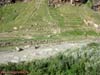
Meadows, used as pastures in the area of dark-coniferous forests in the
foothills of Pir-Pandzhal (Small Himalayas), near the town of Gulmarg, Jammu and Kashmir,
Northern India
Alpine zone with alpine meadows and nival belt at altitudes from 2,500 to
3,500 m above sea level. Foothills of Pir-Pandzhal (Small Himalayas), near the town of
Gulmarg, Jammu and Kashmir, Northern India
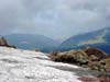
Glacier on the Pier Pandzhal Ridge. View to the dark coniferous forests altitudinal
belt from the nival zone. Small Himalayas, near the town of Gulmarg, 53 km from Sri Nagar,
Jammu and Kashmir, Northern India. Height is about 4100 m above sea level.
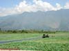
Kashmir valley and Lake Dal with the plantations of Indian lotus - Nelumbo
nucifera (obsolete: Nelumbium speciosum, Nelumbium nelumbo) in the valley between
Pier-Pandzhal and the Great Himalayas Range (Lesser Himalayan foot). Kashmir valley, Jammu
and Kashmir, Northern India
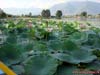
Flowers and leaves of the Indian lotus - Nelumbo nucifera (obsolete:
Nelumbium speciosum, Nelumbium nelumbo) on the plantation on Lake Dal between
Pier-Pandzhal and the Great Himalayas Range (Lesser Himalayan foot). Kashmir valley, Jammu
and Kashmir, Northern India
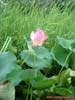
Flower and leaves of the Indian lotus - Nelumbo nucifera (obsolete:
Nelumbium speciosum, Nelumbium nelumbo) on the plantation on Lake Dal between
Pier-Pandzhal and the Great Himalayas Range (Lesser Himalayan foot). Kashmir valley, Jammu
and Kashmir, Northern India Jammu and Kashmir, Northern India
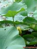
Indian lotus leaves (Nelumbo nucifera) and lily’s leaves and flower. Dal
Lake between Pier Pandzhal and the Great Himalayas Range (Lesser Himalayan foot). Kashmir
valley, Jammu and Kashmir, Northern India
From Photo Nature section of our site you can also download thousands images of fungi, lichens, plants and animals, made by professional Russian field biologists and geographers during their expeditions all over the Russia and former USSR republics. All objects from our collection are determined by scientist and have exact scientific name, date and place of taking picture, as well as size of the original image.
You are able to find necessary pictures using four different approach:
1) with a help of Geographic Index (all objects are separated by countries and nature geographical zones), 2) with a help of Systematic Index (all objects are separated by their systematic position),
3) with a help of Alphabetical Index (all objects are separated by their scientific Latin names according to the alphabet), and
4) with a help of Search Form (you can search scientific (Latin) names of species, genus, family, or order).
Our Field Ecology Center published more than
180 methodical materials for nature studies. Some of them are in English: